
Make a donation
Gear up for your next adventure:
As an Amazon Associate, this site earns from qualifying purchases at no extra cost to you.
Cummings Township topographic map
Click on the map to display elevation.
Make a donation
Gear up for your next adventure:
As an Amazon Associate, this site earns from qualifying purchases at no extra cost to you.
About this map
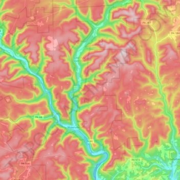
Name: Cummings Township topographic map, elevation, terrain.
Average elevation: 458 m
Minimum elevation: 169 m
Maximum elevation: 671 m
Make a donation
Gear up for your next adventure:
As an Amazon Associate, this site earns from qualifying purchases at no extra cost to you.
Other topographic maps
Click on a map to view its topography, its elevation and its terrain.
Make a donation
Gear up for your next adventure:
As an Amazon Associate, this site earns from qualifying purchases at no extra cost to you.
Elimsport
United States > Pennsylvania > Lycoming County > Washington Township
Average elevation: 192 m
Loyalsockville
United States > Pennsylvania > Lycoming County > Upper Fairfield Township
Average elevation: 262 m
Make a donation
Gear up for your next adventure:
As an Amazon Associate, this site earns from qualifying purchases at no extra cost to you.
Cove Mountain
United States > Pennsylvania > Lycoming County > Gamble Township
Average elevation: 426 m
Cogan Station
United States > Pennsylvania > Lycoming County > Hepburn Township
Average elevation: 242 m
Make a donation
Gear up for your next adventure:
As an Amazon Associate, this site earns from qualifying purchases at no extra cost to you.
Make a donation
Gear up for your next adventure:
As an Amazon Associate, this site earns from qualifying purchases at no extra cost to you.
Raccoon Mountain
United States > Pennsylvania > Lycoming County > Armstrong Township
Average elevation: 379 m
Waterville
United States > Pennsylvania > Lycoming County > Cummings Township
Average elevation: 388 m