
Kota topographic map
Interactive map
Click on the map to display elevation.
About this map
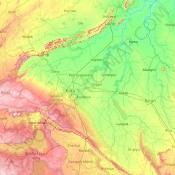
Name: Kota topographic map, elevation, terrain.
Location: Kota, Rajasthan, India (24.54335 75.61720 25.84879 76.59696)
Average elevation: 309 m
Minimum elevation: 181 m
Maximum elevation: 587 m
Other topographic maps
Click on a map to view its topography, its elevation and its terrain.
Merda Khalsa
India > Rajasthan > Amet Tehsil
Merda Khalsa, Amet Tehsil, Rajsamand District, Rajasthan, India
Average elevation: 619 m
Madri
India > Rajasthan > Jhadol Tehsil
Madri, Jhadol Tehsil, Udaipur District, Rajasthan, India
Average elevation: 710 m
Rawatpura Toos
India > Rajasthan > Vallabhnagar Tehsil
Rawatpura Toos, Vallabhnagar Tehsil, Udaipur District, Rajasthan, 313022, India
Average elevation: 515 m
Keoladeo Ghana National Park
Keoladeo Ghana National Park, Agra Jaipur Bikaner Road, Bharatpur, Bharatpur Tehsil, Bharatpur, Rajasthan, 321001, India
Average elevation: 177 m
Sawāi Mādhopur
Sawāi Mādhopur, Sawai Madhopur, Rajasthan, 322200, India
Average elevation: 275 m
Sariska National Park
Sariska National Park, Rajgarh Tehsil, Alwar, Rajasthan, India
Average elevation: 501 m