Geolocate

Carnforth topographic map

Click on the map to display elevation.

About this map
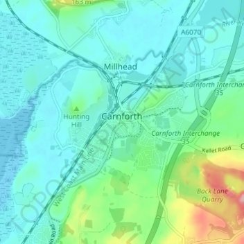
Name: Carnforth topographic map, elevation, terrain.

Location: Carnforth, Warton, Lancaster, Lancashire, England, United Kingdom (54.11237 -2.79634 54.14223 -2.73563)

Average elevation: 28 m

Minimum elevation: 0 m

Maximum elevation: 139 m

Other topographic maps

Click on a map to view its topography, its elevation and its terrain.
Warton Crag

United Kingdom > England > Lancashire > Lancaster > Warton

Average elevation: 45 m

Gear up for your next adventure:

💡Solar Camping Lamp - Eco-friendly lighting for campsites
🔦LED Flashlight - Powerful and long-lasting flashlight for camping and emergencies
🧢Outdoor Cap - Protective cap for sun and rain during hikes
🧥Thermal Layer - Insulating layer for cold outdoor conditions
🥾Durable Hiking Shoes - Long-lasting shoes for frequent hiking

As an Amazon Associate, this site earns from qualifying purchases at no extra cost to you.