Geolocate

Emerald topographic map

Click on the map to display elevation.

About this map

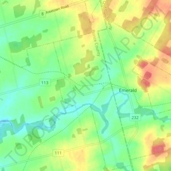
Name: Emerald topographic map, elevation, terrain.

Location: Emerald, Prince County, Prince Edward Island, Canada (46.33757 -63.57560 46.38625 -63.54336)

Average elevation: 44 m

Minimum elevation: 18 m

Maximum elevation: 82 m

Other topographic maps

Click on a map to view its topography, its elevation and its terrain.

Gear up for your next adventure:

🧴Waterproofing Spray - Restore the DWR coating on jackets and tents
🪑Ultralight Camping Stool - Compact seating for rest stops during long hikes
🥾Approach Shoes - Shoes designed for climbing approaches and rugged trails
🧦Hiking Liner Socks - Thin base layer to prevent friction and blisters
🧴Sunscreen SPF - Broad-spectrum sunscreen for outdoor activities

As an Amazon Associate, this site earns from qualifying purchases at no extra cost to you.