Geolocate

Elk Creek topographic map

Click on the map to display elevation.

About this map

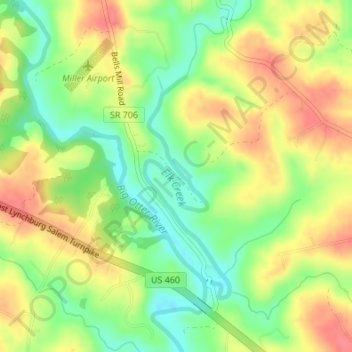
Name: Elk Creek topographic map, elevation, terrain.

Location: Elk Creek, Bedford County, Virginia, United States (37.31094 -79.39959 37.32619 -79.39210)

Average elevation: 218 m

Minimum elevation: 186 m

Maximum elevation: 249 m

Other topographic maps

Click on a map to view its topography, its elevation and its terrain.

Huddleston

United States > Virginia > Bedford County

Average elevation: 226 m

Leesville Lake

United States > Virginia > Bedford County

Average elevation: 247 m

Moneta

United States > Virginia > Bedford County > Moneta

Average elevation: 266 m

Montvale

United States > Virginia > Bedford County > Montvale

Average elevation: 307 m

Goode

United States > Virginia > Bedford County

Average elevation: 253 m

Hardy

United States > Virginia > Bedford County

Average elevation: 289 m

Big Island

United States > Virginia > Bedford County > Big Island > Waugh

Average elevation: 236 m

Union

United States > Virginia > Bedford County

Average elevation: 291 m

Forest

United States > Virginia > Bedford County > Forest

Average elevation: 256 m

Forest

United States > Virginia > Bedford County

Average elevation: 257 m

Bedford

United States > Virginia > Bedford County

Average elevation: 285 m

Huddleston

United States > Virginia > Bedford County

Average elevation: 226 m

Hardy

United States > Virginia > Bedford County

Average elevation: 289 m

Norwood

United States > Virginia > Bedford County > Norwood

Average elevation: 276 m

Gear up for your next adventure:

🧥Insulated Jacket - Keep warm in cold outdoor conditions
👟Trail Running Shoes - Agile footwear for fast-paced topographic exploration
Camping Tent - Weather-resistant tents suitable for 2 to 6 people
🧢Beanie Hat - Keep your head warm in cold weather
🛶Waterproof Dry Bags - Keep electronics and clothes dry during river crossings

As an Amazon Associate, this site earns from qualifying purchases at no extra cost to you.