Geolocate

Santiago topographic map

Click on the map to display elevation.

About this map

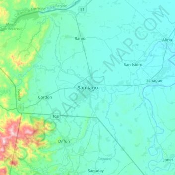
Name: Santiago topographic map, elevation, terrain.

Location: Santiago, Isabela, Cagayan Valley, 3311, Philippines (16.53160 121.38786 16.85160 121.70786)

Average elevation: 146 m

Minimum elevation: 48 m

Maximum elevation: 901 m

Gear up for your next adventure:

🔦LED Headlamp - Hands-free lighting for early morning starts or late finishes
🕯️Camping Lantern - Illuminates your entire campsite with high-efficiency LEDs
🎒Fully Waterproof Backpack - Total protection for photography gear and electronics
🔭Compact Binoculars - Lightweight optics for scouting trails and wildlife
💧Reusable Water Bottle - Durable water bottles for hydration on trails

As an Amazon Associate, this site earns from qualifying purchases at no extra cost to you.