
Make a donation
Gear up for your next adventure:
As an Amazon Associate, this site earns from qualifying purchases at no extra cost to you.
Bleckenstedt topographic map
Click on the map to display elevation.
Make a donation
Gear up for your next adventure:
As an Amazon Associate, this site earns from qualifying purchases at no extra cost to you.
About this map
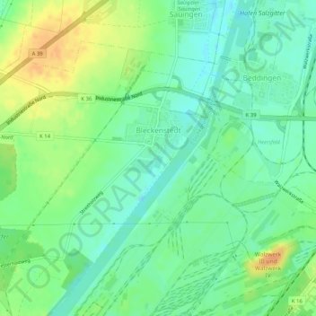
Name: Bleckenstedt topographic map, elevation, terrain.
Average elevation: 93 m
Minimum elevation: 79 m
Maximum elevation: 113 m
Make a donation
Gear up for your next adventure:
As an Amazon Associate, this site earns from qualifying purchases at no extra cost to you.
Other topographic maps
Click on a map to view its topography, its elevation and its terrain.
Salzgitter
Deutschland > Niedersachsen > Salzgitter
Salzgitter liegt in einer breiten lössbedeckten Mulde zwischen dem Oderwald im Osten und den Lichtenbergen (Nordwestteil des Salzgitter-Höhenzugs) im westlichen Teil des Stadtgebiets sowie dem nördlichen Mittelteil des Salzgitter-Höhenzugs im südlichen Stadtgebiet. Die Stadt wird etwa in…
Average elevation: 111 m
Make a donation
Gear up for your next adventure:
As an Amazon Associate, this site earns from qualifying purchases at no extra cost to you.