
Make a donation
Gear up for your next adventure:
As an Amazon Associate, this site earns from qualifying purchases at no extra cost to you.
Salzgitter topographic map
Click on the map to display elevation.
Make a donation
Gear up for your next adventure:
As an Amazon Associate, this site earns from qualifying purchases at no extra cost to you.
Salzgitter
Salzgitter liegt in einer breiten lössbedeckten Mulde zwischen dem Oderwald im Osten und den Lichtenbergen (Nordwestteil des Salzgitter-Höhenzugs) im westlichen Teil des Stadtgebiets sowie dem nördlichen Mittelteil des Salzgitter-Höhenzugs im südlichen Stadtgebiet. Die Stadt wird etwa in Nordwest-Südost-Richtung vom Oberlauf der Fuhse durchflossen. Der Mittellauf der Innerste fließt wenige Kilometer durch den äußersten Südwesten Salzgitters.
Make a donation
Gear up for your next adventure:
As an Amazon Associate, this site earns from qualifying purchases at no extra cost to you.
About this map
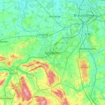
Name: Salzgitter topographic map, elevation, terrain.
Location: Salzgitter, Niedersachsen, 38226, Deutschland (51.99037 10.19931 52.31037 10.51931)
Average elevation: 111 m
Minimum elevation: 63 m
Maximum elevation: 306 m
Make a donation
Gear up for your next adventure:
As an Amazon Associate, this site earns from qualifying purchases at no extra cost to you.
Other topographic maps
Click on a map to view its topography, its elevation and its terrain.
Make a donation
Gear up for your next adventure:
As an Amazon Associate, this site earns from qualifying purchases at no extra cost to you.
Make a donation
Gear up for your next adventure:
As an Amazon Associate, this site earns from qualifying purchases at no extra cost to you.
Make a donation
Gear up for your next adventure:
As an Amazon Associate, this site earns from qualifying purchases at no extra cost to you.