
Make a donation
Gear up for your next adventure:
As an Amazon Associate, this site earns from qualifying purchases at no extra cost to you.
North Rauceby topographic map
Click on the map to display elevation.
Make a donation
Gear up for your next adventure:
As an Amazon Associate, this site earns from qualifying purchases at no extra cost to you.
About this map
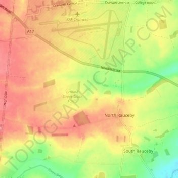
Name: North Rauceby topographic map, elevation, terrain.
Average elevation: 59 m
Minimum elevation: 17 m
Maximum elevation: 87 m
Make a donation
Gear up for your next adventure:
As an Amazon Associate, this site earns from qualifying purchases at no extra cost to you.
Other topographic maps
Click on a map to view its topography, its elevation and its terrain.
Sleaford
United Kingdom > England > North Kesteven > Sleaford
Although largely undamaged in the First and Second World Wars, Sleaford has close links with the Royal Air Force due to its proximity to several RAF bases, including RAF Cranwell and RAF Waddington. Lincolnshire's topography—flat and open countryside—and its location on the east of the country made it…
Average elevation: 21 m
Ashby de la Launde
United Kingdom > England > North Kesteven > Ashby de la Launde
Average elevation: 30 m