
Martinborough Community topographic map
Click on the map to display elevation.
About this map
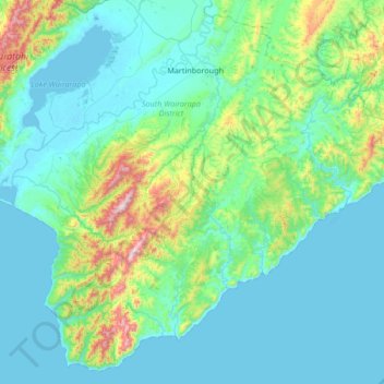
Name: Martinborough Community topographic map, elevation, terrain.
Average elevation: 141 m
Minimum elevation: -2 m
Maximum elevation: 968 m
Other topographic maps
Click on a map to view its topography, its elevation and its terrain.
Featherston
New Zealand > Wellington > South Wairarapa District > Featherston Community
Average elevation: 125 m
Greytown
New Zealand > Wellington > South Wairarapa District > Greytown Community
Average elevation: 59 m
Lake Ferry
New Zealand > Wellington > South Wairarapa District > Martinborough Community
Average elevation: 16 m
Mount Matthews
New Zealand > Wellington > South Wairarapa District > Featherston Community
Average elevation: 535 m
Martinborough
New Zealand > Wellington > South Wairarapa District > Martinborough Community
Average elevation: 46 m
Greytown
New Zealand > Wellington > South Wairarapa District > Greytown Community
Average elevation: 59 m
South Featherston
New Zealand > Wellington > South Wairarapa District > Featherston Community > Featherston
Average elevation: 26 m
South Featherston
New Zealand > Wellington > South Wairarapa District > Featherston Community > Featherston
Average elevation: 26 m
South Featherston
New Zealand > Wellington > South Wairarapa District > Featherston Community > Featherston
Average elevation: 26 m
Glendhu
New Zealand > Wellington > South Wairarapa District > Martinborough Community
Average elevation: 87 m
Featherston
New Zealand > Wellington > South Wairarapa District > Featherston Community
Average elevation: 125 m
Start
New Zealand > Wellington > South Wairarapa District > Martinborough Community
Average elevation: 255 m
Featherston
New Zealand > Wellington > South Wairarapa District > Featherston Community
Average elevation: 125 m
Featherston
New Zealand > Wellington > South Wairarapa District > Featherston Community
Average elevation: 125 m
Greytown
New Zealand > Wellington > South Wairarapa District > Greytown Community
Average elevation: 59 m
Greytown
New Zealand > Wellington > South Wairarapa District > Greytown Community
Average elevation: 59 m
South Featherston
New Zealand > Wellington > South Wairarapa District > Featherston Community > Featherston
Average elevation: 26 m
Lake Ōnoke
New Zealand > Wellington > South Wairarapa District > Featherston Community
Average elevation: 2 m