Geolocate

Greytown topographic map

Click on the map to display elevation.

About this map

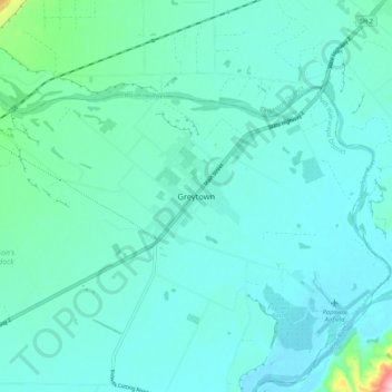
Name: Greytown topographic map, elevation, terrain.

Location: Greytown, Greytown Community, South Wairarapa District, Wellington, 5712, New Zealand (-41.12063 175.42055 -41.04063 175.50055)

Average elevation: 59 m

Minimum elevation: 32 m

Maximum elevation: 238 m

Gear up for your next adventure:

🥘Camping Cookware Set - Compact nesting pots and pans for trail cooking
🔦UV Flashlight - Detect minerals or specific insects in the dark
🧭GPS Handheld Device - Reliable GPS navigation for outdoor adventures
🥾Trekking Poles - Adjustable trekking poles to reduce knee stress and improve stability
🧢Hiking Hat - Sun-protective and breathable hats for long treks

As an Amazon Associate, this site earns from qualifying purchases at no extra cost to you.