
Town of Shediac topographic map
Click on the map to display elevation.
About this map
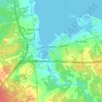
Name: Town of Shediac topographic map, elevation, terrain.
Location: Town of Shediac, Westmorland County, New Brunswick, Canada (46.08435 -64.66668 46.28112 -64.46296)
Average elevation: 28 m
Minimum elevation: -3 m
Maximum elevation: 76 m
Westmorland County trails, hiking, mountain biking, running and outdoor activities
Other topographic maps
Click on a map to view its topography, its elevation and its terrain.
Memramcook Lake
Canada > New Brunswick > Westmorland County > Dorchester Parish
Average elevation: 19 m
Haute-Aboujagane
Canada > New Brunswick > Westmorland County > Beaubassin East
Average elevation: 28 m