Geolocate

Driffield topographic map

Click on the map to display elevation.

About this map

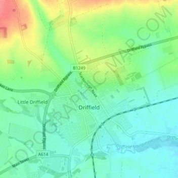
Name: Driffield topographic map, elevation, terrain.

Location: Driffield, East Riding of Yorkshire, England, United Kingdom (53.99244 -0.46758 54.02817 -0.39647)

Average elevation: 27 m

Minimum elevation: 7 m

Maximum elevation: 75 m

Other topographic maps

Click on a map to view its topography, its elevation and its terrain.

Gear up for your next adventure:

🎒Fully Waterproof Backpack - Total protection for photography gear and electronics
💡Compact LED Flashlight - Powerful and portable flashlight for outdoor use
🧦Thermal Socks - Warm socks for winter hiking or camping
🕯️Camping Lantern - Illuminates your entire campsite with high-efficiency LEDs
👟Sport Hiking Sandals - Breathable footwear for water crossings and camp rest

As an Amazon Associate, this site earns from qualifying purchases at no extra cost to you.