Geolocate

Telscombe topographic map

Click on the map to display elevation.

About this map

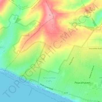
Name: Telscombe topographic map, elevation, terrain.

Location: Telscombe, Lewes, East Sussex, England, United Kingdom (50.79066 -0.03878 50.82006 0.00440)

Average elevation: 55 m

Minimum elevation: 0 m

Maximum elevation: 126 m

Gear up for your next adventure:

🔨Vehicle Emergency Tool - Safety tool for remote road trips to trailheads
🥾Hiking Shorts - Breathable shorts suitable for summer hikes
🔦LED Headlamp - Hands-free lighting for early morning starts or late finishes
🪜Heavy Duty Carabiners - Multi-use clips for securing gear to your backpack
🥾Trail Running Boots - Durable shoes designed for trail running

As an Amazon Associate, this site earns from qualifying purchases at no extra cost to you.