Geolocate

Caego topographic map

Click on the map to display elevation.

About this map

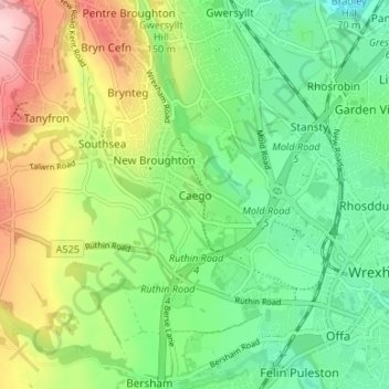
Name: Caego topographic map, elevation, terrain.

Location: Caego, Wrexham, Wales, LL11 6YP, United Kingdom (53.03444 -3.04541 53.07444 -3.00541)

Average elevation: 121 m

Minimum elevation: 47 m

Maximum elevation: 248 m

Other topographic maps

Click on a map to view its topography, its elevation and its terrain.

Gwersyllt

United Kingdom > Wales > Wrexham

Average elevation: 112 m

Penycae

United Kingdom > Wales > Wrexham

Average elevation: 350 m

Rhosddu

United Kingdom > Wales > Wrexham

Average elevation: 88 m

Cefn

United Kingdom > Wales > Wrexham > Acrefair

Average elevation: 142 m

Bangor-on-Dee

United Kingdom > Wales > Wrexham

Average elevation: 30 m

Gear up for your next adventure:

🔭Outdoor Binoculars - Lightweight binoculars for birdwatching and hiking
🗺️Topographic Maps - Detailed maps to explore trails, mountains, and wilderness areas
🧥Softshell Hiking Jacket - The perfect balance of wind protection and breathability
🛌Insulated Sleeping Pad - Critical thermal barrier between you and the cold ground
🛌Down Sleeping Bag - Superior warmth-to-weight ratio for cold nights

As an Amazon Associate, this site earns from qualifying purchases at no extra cost to you.