Geolocate

Garabit topographic map

Click on the map to display elevation.

About this map

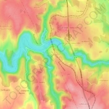
Name: Garabit topographic map, elevation, terrain.

Location: Garabit, Loubaresse, Val d'Arcomie, Saint-Flour, Cantal, Auvergne-Rhône-Alpes, France métropolitaine, 15320, France (44.95088 3.15863 44.99088 3.19863)

Average elevation: 825 m

Minimum elevation: 721 m

Maximum elevation: 893 m

Other topographic maps

Click on a map to view its topography, its elevation and its terrain.

15320

France > Auvergne-Rhône-Alpes > Cantal > Val d'Arcomie

Average elevation: 842 m

Gear up for your next adventure:

🧥Softshell Hiking Jacket - The perfect balance of wind protection and breathability
🗺️Topographic Maps - Detailed maps to explore trails, mountains, and wilderness areas
🛰️Satellite Messenger - Emergency communication for areas with no cell service
🧣Merino Neck Gaiter - Protects against wind, sun, and cold at high altitudes
🧦Outdoor Socks - Durable socks designed for hiking and outdoor sports

As an Amazon Associate, this site earns from qualifying purchases at no extra cost to you.