
Saint-Just topographic map
Click on the map to display elevation.
About this map
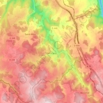
Name: Saint-Just topographic map, elevation, terrain.
Average elevation: 986 m
Minimum elevation: 765 m
Maximum elevation: 1,103 m
Other topographic maps
Click on a map to view its topography, its elevation and its terrain.
Le Chassan
France > Auvergne-Rhône-Alpes > Cantal > Val d'Arcomie > Faverolles
Average elevation: 882 m
Montchanson
France > Auvergne-Rhône-Alpes > Cantal > Val d'Arcomie > Faverolles
Average elevation: 943 m
Lascoux
France > Auvergne-Rhône-Alpes > Cantal > Val d'Arcomie > Saint-Just > Lascoux
Average elevation: 957 m
La Brugère
France > Auvergne-Rhône-Alpes > Cantal > Val d'Arcomie > Faverolles > La Brugère
Average elevation: 831 m
Le Moulin des Mazes
France > Auvergne-Rhône-Alpes > Cantal > Val d'Arcomie > Saint-Marc > Le Moulin des Mazes
Average elevation: 949 m
Estrémiac
France > Auvergne-Rhône-Alpes > Cantal > Val d'Arcomie > Saint-Just > Estrémiac
Average elevation: 977 m