
Make a donation
Gear up for your next adventure:
As an Amazon Associate, this site earns from qualifying purchases at no extra cost to you.
Changaimina topographic map
Click on the map to display elevation.
Make a donation
Gear up for your next adventure:
As an Amazon Associate, this site earns from qualifying purchases at no extra cost to you.
Changaimina
La hidrografía de CHangaimina tiene su origen en su principal elevación, la cordillera de La Panuma. Se caracteriza por tener algunas vertientes de agua dulce, que constituyen la fuente vital para las necesidades agrícolas y de consumo humano, estas son: El río Catamayo, La Quebrada Grande, La Quebrada de Chamana, La Quebrada de San Carlos, La Quebrada de Lanzaca, etc.
Make a donation
Gear up for your next adventure:
As an Amazon Associate, this site earns from qualifying purchases at no extra cost to you.
About this map
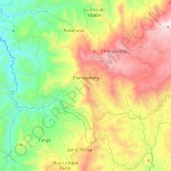
Name: Changaimina topographic map, elevation, terrain.
Location: Changaimina, Gonzanama, Loja, 110603, Ecuador (-4.29742 -79.60776 -4.16019 -79.46720)
Average elevation: 1,645 m
Minimum elevation: 917 m
Maximum elevation: 2,647 m
Make a donation
Gear up for your next adventure:
As an Amazon Associate, this site earns from qualifying purchases at no extra cost to you.
Other topographic maps
Click on a map to view its topography, its elevation and its terrain.