
Make a donation
Gear up for your next adventure:
As an Amazon Associate, this site earns from qualifying purchases at no extra cost to you.
Rannerdale Knotts topographic map
Click on the map to display elevation.
Make a donation
Gear up for your next adventure:
As an Amazon Associate, this site earns from qualifying purchases at no extra cost to you.
Rannerdale Knotts
The highest ground in the North Western Fells is an east-west ridge in this central sector, beginning with Grasmoor above Crummock Water and then gradually descending eastwards over Crag Hill, Sail, Scar Crags and Causey Pike. Grasmoor has the greatest elevation, but Crag Hill stands at the hub of the range. It sends out a subsidiary ridge to the south west, stepping down over Wandope and Whiteless Pike toward Buttermere village. Just above the village this ridge then turns sharply north west and rises to the summit of Rannerdale Knotts.
Make a donation
Gear up for your next adventure:
As an Amazon Associate, this site earns from qualifying purchases at no extra cost to you.
About this map
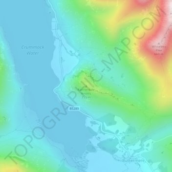
Name: Rannerdale Knotts topographic map, elevation, terrain.
Average elevation: 212 m
Minimum elevation: 99 m
Maximum elevation: 660 m
Make a donation
Gear up for your next adventure:
As an Amazon Associate, this site earns from qualifying purchases at no extra cost to you.