Geolocate

Ladonia topographic map

Click on the map to display elevation.

About this map

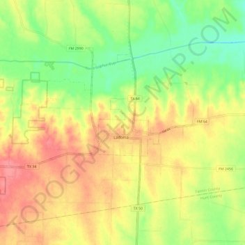
Name: Ladonia topographic map, elevation, terrain.

Location: Ladonia, Fannin County, Texas, 75449, United States (33.39898 -96.02121 33.46324 -95.90625)

Average elevation: 178 m

Minimum elevation: 142 m

Maximum elevation: 212 m

Other topographic maps

Click on a map to view its topography, its elevation and its terrain.

Boyd

United States > Texas > Fannin County

Average elevation: 184 m

Post Oak

United States > Texas > Fannin County

Average elevation: 179 m

Randolph

United States > Texas > Fannin County

Average elevation: 201 m

Indian Creek

United States > Texas > Fannin County > Trenton

Average elevation: 217 m

Ravenna

United States > Texas > Fannin County > Ravenna

Average elevation: 177 m

Gear up for your next adventure:

🥾Trail Hiking Socks - Comfortable socks to prevent blisters and fatigue
🥾Approach Boots - Comfortable boots for hiking and climbing approaches
🧥Softshell Jacket - Windproof and breathable jacket for hiking
💡Solar Camping Lamp - Eco-friendly lighting for campsites
🔋Solar Power Bank - Keep your GPS and devices charged during long outdoor trips

As an Amazon Associate, this site earns from qualifying purchases at no extra cost to you.