Geolocate

Mejia topographic map

Click on the map to display elevation.

About this map

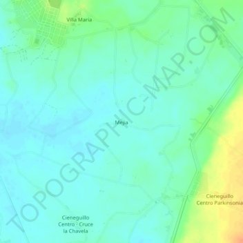
Name: Mejia topographic map, elevation, terrain.

Location: Mejia, Sullana, Province of Sullana, Piura, Peru (-4.96213 -80.66892 -4.92213 -80.62892)

Average elevation: 77 m

Minimum elevation: 67 m

Maximum elevation: 105 m

Other topographic maps

Click on a map to view its topography, its elevation and its terrain.

Chira

Peru > Piura > Sullana

Average elevation: 50 m

Gear up for your next adventure:

🥾Trail Hiking Boots - Supportive boots for rough trails
🔥Emergency Fire Starter - Reliable ignition source for all weather conditions
🥾Waterproof Hiking Shoes - Durable shoes for wet and rugged trails
🌡️Emergency Mylar Blankets - Compact thermal protection for unexpected nights outdoors
🪑Insulated Seat Pad - Protect your seat from cold rocks and wet logs

As an Amazon Associate, this site earns from qualifying purchases at no extra cost to you.