
Belvedere topographic map
Interactive map
Click on the map to display elevation.
About this map
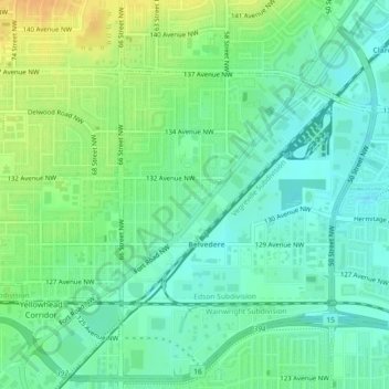
Name: Belvedere topographic map, elevation, terrain.
Location: Belvedere, Edmonton, Alberta, T5A 0V5, Canada (53.58240 -113.44298 53.59969 -113.41809)
Average elevation: 661 m
Minimum elevation: 649 m
Maximum elevation: 681 m
Other topographic maps
Click on a map to view its topography, its elevation and its terrain.
Lake District
Lake District, Edmonton, Alberta, Canada
Average elevation: 684 m
Lakewood
Canada > Alberta > Edmonton > Mill Woods
Lakewood, Mill Woods, Edmonton, Alberta, Canada
Average elevation: 689 m
The Meadows District
Larkspur, West Meadows, The Meadows District, Edmonton, Alberta, Canada
Average elevation: 707 m
Central Core
Downtown, Central Core, Edmonton, Alberta, Canada
Average elevation: 653 m
The Meadows
Tamarack, The Meadows, Edmonton, Alberta, Canada
Average elevation: 718 m