Geolocate

Edmonton topographic map

Click on the map to display elevation.

About this map

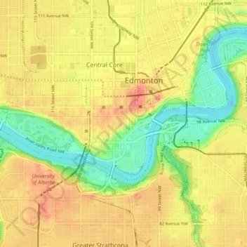
Name: Edmonton topographic map, elevation, terrain.

Location: Central Core, Edmonton, Alberta, Canada (53.51408 -113.53737 53.56115 -113.45588)

Average elevation: 658 m

Minimum elevation: 610 m

Maximum elevation: 702 m

Alberta trails, hiking, mountain biking, running and outdoor activities

Other topographic maps

Click on a map to view its topography, its elevation and its terrain.

William Hawrelak Park

Canada > Alberta > Edmonton

Average elevation: 649 m

Horseshoe Lake

Canada > Alberta > Edmonton

Average elevation: 680 m

landslide

Canada > Alberta > Edmonton

Average elevation: 668 m

Ormsby Park

Canada > Alberta > Edmonton

Average elevation: 688 m

Gear up for your next adventure:

Lightweight Camping Tent - Portable shelter optimized for Canadian backcountry camping
🧴Waterproofing Spray - Restore the DWR coating on jackets and tents
🥤Collapsible Travel Cup - Saves space and weight in your mess kit
🧴Insect Repellent - Protect yourself from bugs during outdoor adventures
🚲Bike Repair Kit - Essential tools for on-trail mechanical issues

As an Amazon Associate, this site earns from qualifying purchases at no extra cost to you.