Geolocate

Roseville topographic map

Click on the map to display elevation.

About this map

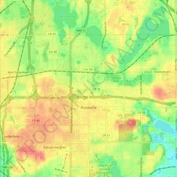
Name: Roseville topographic map, elevation, terrain.

Location: Roseville, Ramsey County, Minnesota, 55113, United States (44.99176 -93.20812 45.03590 -93.10588)

Average elevation: 284 m

Minimum elevation: 253 m

Maximum elevation: 311 m

Other topographic maps

Click on a map to view its topography, its elevation and its terrain.

Gladstone

United States > Minnesota > Ramsey County > Maplewood

Average elevation: 285 m

Midvale

United States > Minnesota > Ramsey County > Maplewood

Average elevation: 305 m

Como Lake

United States > Minnesota > Ramsey County > Saint Paul

Average elevation: 280 m

Gear up for your next adventure:

🥾Lightweight Hiking Shoes - Comfortable shoes for day hikes
🧢Outdoor Cap - Protective cap for sun and rain during hikes
Backpacking Tent - Lightweight tent for long-distance hiking trips
🔪Outdoor Multitool - Versatile tool for repairs and food prep in the wild
🎒Fully Waterproof Backpack - Total protection for photography gear and electronics

As an Amazon Associate, this site earns from qualifying purchases at no extra cost to you.