
Buri Ram Province topographic map
Interactive map
Click on the map to display elevation.
About this map
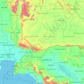
Name: Buri Ram Province topographic map, elevation, terrain.
Location: Buri Ram Province, Thailand (12.05071 100.08532 17.17071 105.20532)
Average elevation: 146 m
Minimum elevation: -2 m
Maximum elevation: 1,753 m
Other topographic maps
Click on a map to view its topography, its elevation and its terrain.