
Make a donation
Gear up for your next adventure:
As an Amazon Associate, this site earns from qualifying purchases at no extra cost to you.
Anatone topographic map
Click on the map to display elevation.
Make a donation
Gear up for your next adventure:
As an Amazon Associate, this site earns from qualifying purchases at no extra cost to you.
About this map
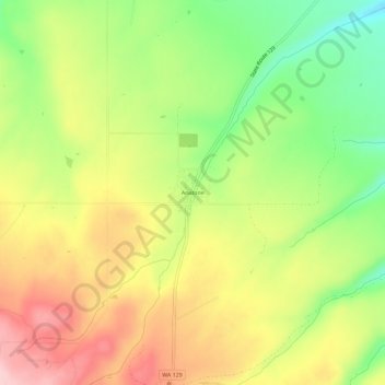
Name: Anatone topographic map, elevation, terrain.
Location: Anatone, Asotin County, Washington, United States (46.11479 -117.15230 46.15479 -117.11230)
Average elevation: 1,097 m
Minimum elevation: 1,002 m
Maximum elevation: 1,192 m
Make a donation
Gear up for your next adventure:
As an Amazon Associate, this site earns from qualifying purchases at no extra cost to you.
Other topographic maps
Click on a map to view its topography, its elevation and its terrain.
Asotin
United States > Washington > Asotin County
Asotin is located south of Clarkston, on the west bank of the Snake River. The elevation is 801 feet (244 m) above sea level.
Average elevation: 319 m