
Make a donation
Gear up for your next adventure:
As an Amazon Associate, this site earns from qualifying purchases at no extra cost to you.
Asotin topographic map
Click on the map to display elevation.
Make a donation
Gear up for your next adventure:
As an Amazon Associate, this site earns from qualifying purchases at no extra cost to you.
Asotin
Asotin is located south of Clarkston, on the west bank of the Snake River. The elevation is 801 feet (244 m) above sea level.
Make a donation
Gear up for your next adventure:
As an Amazon Associate, this site earns from qualifying purchases at no extra cost to you.
About this map
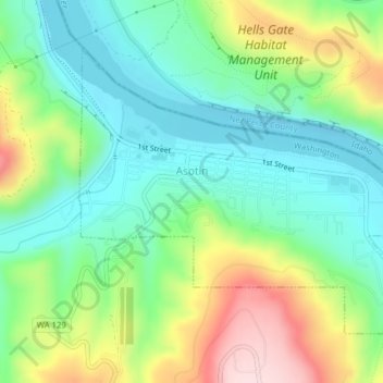
Name: Asotin topographic map, elevation, terrain.
Location: Asotin, Asotin County, Washington, 99402, United States (46.32783 -117.05974 46.34787 -117.02315)
Average elevation: 319 m
Minimum elevation: 217 m
Maximum elevation: 519 m
Make a donation
Gear up for your next adventure:
As an Amazon Associate, this site earns from qualifying purchases at no extra cost to you.
Other topographic maps
Click on a map to view its topography, its elevation and its terrain.