
West Byfleet topographic map
Click on the map to display elevation.
West Byfleet
The surface undulates gently from the west to the east, where West Byfleet's land is drained in the parish of Byfleet itself by the River Wey. Soil ranges from sandy acidic soil in the west to more alluvial soil in the east, underlain by a mixture of gravel and clay. Elevations range from 18m Above Ordnance Datum to 33m.
About this map
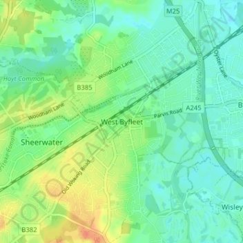
Name: West Byfleet topographic map, elevation, terrain.
Average elevation: 26 m
Minimum elevation: 13 m
Maximum elevation: 52 m
Other topographic maps
Click on a map to view its topography, its elevation and its terrain.
Horsell Common
United Kingdom > England > Surrey > Woking > Horsell > Durnford Farm
Average elevation: 29 m