
Make a donation
Gear up for your next adventure:
As an Amazon Associate, this site earns from qualifying purchases at no extra cost to you.
Anglès topographic map
Click on the map to display elevation.
Make a donation
Gear up for your next adventure:
As an Amazon Associate, this site earns from qualifying purchases at no extra cost to you.
Anglès
La villa gerundense se sitúa en medio de un extenso valle que dista 17 km de Gerona, 12 km de Santa Coloma de Farnés (capital de la comarca), 100 km de la ciudad de Barcelona y 40 km de la Costa Brava. La villa antigua se alza sobre una pequeña elevación situada en medio de una llanura fértil en el lado sur de la desembocadura de la riera de Osor en el río Ter, corriente de agua que marca la frontera entre Anglés y la Cellera de Ter, y de Anglés y el municipio de Sant Julià del Llor i Bonmatí.
Make a donation
Gear up for your next adventure:
As an Amazon Associate, this site earns from qualifying purchases at no extra cost to you.
About this map
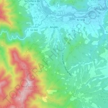
Name: Anglès topographic map, elevation, terrain.
Location: Anglès, la Selva, Gerona, Cataluña, 17160, España (41.91997 2.59989 41.96348 2.67608)
Average elevation: 315 m
Minimum elevation: 127 m
Maximum elevation: 832 m
Make a donation
Gear up for your next adventure:
As an Amazon Associate, this site earns from qualifying purchases at no extra cost to you.
Other topographic maps
Click on a map to view its topography, its elevation and its terrain.
Make a donation
Gear up for your next adventure:
As an Amazon Associate, this site earns from qualifying purchases at no extra cost to you.
Castell de Sant Joan
España > Cataluña > la Selva > Blanes
La torre de San Juan (en catalán, torre de Sant Joan) es una fortificación española situada en la cima del cerro San Juan en Blanes (Gerona). Desde allí, a 180 metros de altitud, se puede contemplar una vista de la ciudad y la comarca de la Selva y, por el sur, en los días despejados, se puede llegar a…
Average elevation: 33 m
Make a donation
Gear up for your next adventure:
As an Amazon Associate, this site earns from qualifying purchases at no extra cost to you.
Make a donation
Gear up for your next adventure:
As an Amazon Associate, this site earns from qualifying purchases at no extra cost to you.