Geolocate

Madeley topographic map

Click on the map to display elevation.

About this map

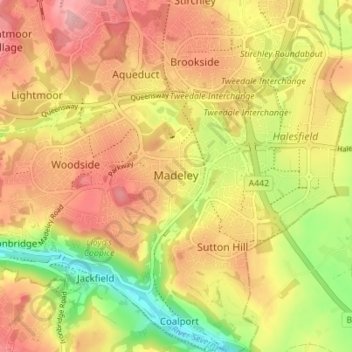
Name: Madeley topographic map, elevation, terrain.

Location: Madeley, Telford and Wrekin, England, United Kingdom (52.61783 -2.48549 52.65444 -2.41647)

Average elevation: 116 m

Minimum elevation: 37 m

Maximum elevation: 176 m

Other topographic maps

Click on a map to view its topography, its elevation and its terrain.

Telford

United Kingdom > England > Telford and Wrekin

Average elevation: 136 m

Dawley

United Kingdom > England > Telford and Wrekin

Average elevation: 142 m

Telford

United Kingdom > England > Telford and Wrekin

Average elevation: 136 m

Ironbridge

United Kingdom > England > Telford and Wrekin

Average elevation: 126 m

Telford

United Kingdom > England > Telford and Wrekin

Average elevation: 136 m

Ironbridge

United Kingdom > England > Telford and Wrekin

Average elevation: 126 m

Telford

United Kingdom > England > Telford and Wrekin

Average elevation: 136 m

Telford

United Kingdom > England > Telford and Wrekin

Average elevation: 136 m

Allscott

United Kingdom > England > Telford and Wrekin

Average elevation: 70 m

Jackfield

United Kingdom > England > Telford and Wrekin

Average elevation: 119 m

Play Park

United Kingdom > England > Telford and Wrekin > Dawley

Average elevation: 176 m

Dawley

United Kingdom > England > Telford and Wrekin

Average elevation: 142 m

Telford

United Kingdom > England > Telford and Wrekin

Average elevation: 136 m

Gear up for your next adventure:

🩹Moleskin Blister Pads - Direct protection for painful foot pressure points
🥾Lightweight Hiking Shoes - Comfortable shoes for day hikes
🥾Trekking Poles - Adjustable trekking poles to reduce knee stress and improve stability
🧴Waterproofing Spray - Restore the DWR coating on jackets and tents
🧤Thermal Hiking Gloves - Grip-enhanced gloves for cold-weather altitude trekking

As an Amazon Associate, this site earns from qualifying purchases at no extra cost to you.