
Make a donation
Gear up for your next adventure:
As an Amazon Associate, this site earns from qualifying purchases at no extra cost to you.
La Vallée Heureuse topographic map
Click on the map to display elevation.
Make a donation
Gear up for your next adventure:
As an Amazon Associate, this site earns from qualifying purchases at no extra cost to you.
About this map
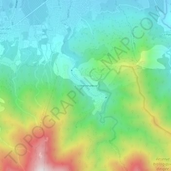
Name: La Vallée Heureuse topographic map, elevation, terrain.
Average elevation: 349 m
Minimum elevation: 71 m
Maximum elevation: 974 m
Make a donation
Gear up for your next adventure:
As an Amazon Associate, this site earns from qualifying purchases at no extra cost to you.
Other topographic maps
Click on a map to view its topography, its elevation and its terrain.
La Massane
France > Occitanie > Pyrénées-Orientales > Sorède
D'une longueur de 22,1 km, la Massane se jette en mer Méditerranée dans le port d'Argelès-sur-Mer. Elle prend source au col de la Maçana, à l'altitude 968 mètres, sur la commune d'Argelès-sur-Mer.
Average elevation: 363 m
Make a donation
Gear up for your next adventure:
As an Amazon Associate, this site earns from qualifying purchases at no extra cost to you.