
Make a donation
Gear up for your next adventure:
As an Amazon Associate, this site earns from qualifying purchases at no extra cost to you.
La Massane topographic map
Click on the map to display elevation.
Make a donation
Gear up for your next adventure:
As an Amazon Associate, this site earns from qualifying purchases at no extra cost to you.
La Massane
D'une longueur de 22,1 km, la Massane se jette en mer Méditerranée dans le port d'Argelès-sur-Mer. Elle prend source au col de la Maçana, à l'altitude 968 mètres, sur la commune d'Argelès-sur-Mer.
Make a donation
Gear up for your next adventure:
As an Amazon Associate, this site earns from qualifying purchases at no extra cost to you.
About this map
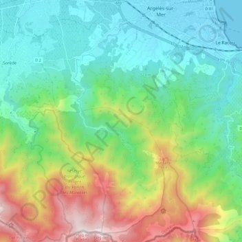
Name: La Massane topographic map, elevation, terrain.
Average elevation: 363 m
Minimum elevation: -2 m
Maximum elevation: 1,163 m
Make a donation
Gear up for your next adventure:
As an Amazon Associate, this site earns from qualifying purchases at no extra cost to you.
Other topographic maps
Click on a map to view its topography, its elevation and its terrain.
Make a donation
Gear up for your next adventure:
As an Amazon Associate, this site earns from qualifying purchases at no extra cost to you.