Geolocate

Buchanan topographic map

Click on the map to display elevation.

About this map

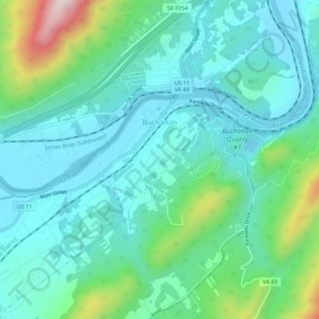
Name: Buchanan topographic map, elevation, terrain.

Location: Buchanan, Botetourt County, Virginia, 24066, United States (37.50360 -79.71564 37.54203 -79.66752)

Average elevation: 344 m

Minimum elevation: 240 m

Maximum elevation: 723 m

Other topographic maps

Click on a map to view its topography, its elevation and its terrain.

Oriskany

United States > Virginia > Botetourt County

Average elevation: 404 m

Eagle Rock

United States > Virginia > Botetourt County

Average elevation: 379 m

Glen Wilton

United States > Virginia > Botetourt County

Average elevation: 363 m

Daleville

United States > Virginia > Botetourt County

Average elevation: 410 m

Haden

United States > Virginia > Botetourt County > Haden

Average elevation: 339 m

Gear up for your next adventure:

🛏️Sleeping Bag - Warm and compact sleeping bags for outdoor camping
🔭Compact Binoculars - Lightweight optics for scouting trails and wildlife
Lightweight Camping Tent - Portable shelter optimized for Canadian backcountry camping
🥾Trekking Boots - Durable boots for long-distance trekking
🧥Thermal Fleece Jacket - Versatile insulation for changing mountain temperatures

As an Amazon Associate, this site earns from qualifying purchases at no extra cost to you.