
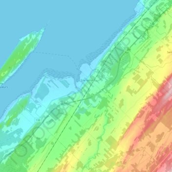
L'Isle-Verte topographic map
Interactive map
Click on the map to display elevation.
About this map
Name: L'Isle-Verte topographic map, elevation, terrain.
Average elevation: 53 m
Minimum elevation: -1 m
Maximum elevation: 238 m
Other topographic maps
Click on a map to view its topography, its elevation and its terrain.
Saint-Antonin
Canada > Quebec > Rivière-du-Loup (MRC)
Saint-Antonin, Rivière-du-Loup (MRC), Bas-Saint-Laurent, Quebec, G0L 2J0, Canada
Average elevation: 188 m
Lac des Roches
Canada > Quebec > Rivière-du-Loup (MRC) > Saint-Paul-de-la-Croix
Lac des Roches, Saint-Paul-de-la-Croix, Rivière-du-Loup (MRC), Bas-Saint-Laurent, Quebec, Canada
Average elevation: 200 m
Lac A
Canada > Quebec > Rivière-du-Loup (MRC) > Saint-Modeste
Lac A, Saint-Modeste, Rivière-du-Loup (MRC), Bas-Saint-Laurent, Quebec, Canada
Average elevation: 201 m
Saint-Modeste
Canada > Quebec > Rivière-du-Loup (MRC)
Saint-Modeste, Rivière-du-Loup (MRC), Bas-Saint-Laurent, Quebec, Canada
Average elevation: 173 m
Rivière-du-Loup
Canada > Quebec > Rivière-du-Loup (MRC)
Rivière-du-Loup, Rivière-du-Loup (MRC), Bas-Saint-Laurent, Quebec, Canada
Average elevation: 64 m