
Saint-Modeste topographic map
Interactive map
Click on the map to display elevation.
About this map
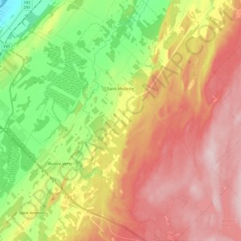
Name: Saint-Modeste topographic map, elevation, terrain.
Average elevation: 173 m
Minimum elevation: 32 m
Maximum elevation: 311 m
Rivière-du-Loup (MRC) trails, hiking, mountain biking, running and outdoor activities
Other topographic maps
Click on a map to view its topography, its elevation and its terrain.
Lac des Roches
Canada > Quebec > Rivière-du-Loup (MRC) > Saint-Paul-de-la-Croix
Average elevation: 200 m