Geolocate

Fishtown topographic map

Click on the map to display elevation.

About this map

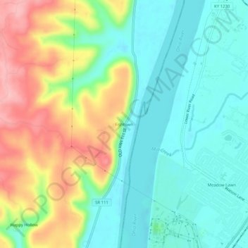
Name: Fishtown topographic map, elevation, terrain.

Location: Fishtown, Harrison County, Indiana, United States (38.04952 -85.93746 38.08952 -85.89746)

Average elevation: 171 m

Minimum elevation: 121 m

Maximum elevation: 266 m

Other topographic maps

Click on a map to view its topography, its elevation and its terrain.

Lanesville

United States > Indiana > Harrison County

Average elevation: 239 m

New Amsterdam

United States > Indiana > Harrison County

Average elevation: 151 m

New Middletown

United States > Indiana > Harrison County

Average elevation: 215 m

Crandall

United States > Indiana > Harrison County

Average elevation: 217 m

Laconia

United States > Indiana > Harrison County

Average elevation: 201 m

Gear up for your next adventure:

🚲Heavy Duty Bike Lock - Secure your bike at the trailhead or during stops
💧Collapsible Water Bottle - Space-saving water bottle for outdoor activities
Camping Coffee Maker - Brew fresh coffee anywhere on the topographic map
🧴Insect Repellent - Protect yourself from bugs during outdoor adventures
🥾Waterproof Hiking Shoes - Durable shoes for wet and rugged trails

As an Amazon Associate, this site earns from qualifying purchases at no extra cost to you.