Geolocate

Crandall topographic map

Click on the map to display elevation.

About this map

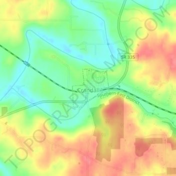
Name: Crandall topographic map, elevation, terrain.

Location: Crandall, Harrison County, Indiana, United States (38.28495 -86.06948 38.29079 -86.06222)

Average elevation: 217 m

Minimum elevation: 184 m

Maximum elevation: 250 m

Other topographic maps

Click on a map to view its topography, its elevation and its terrain.

Macedonia

United States > Indiana > Harrison County

Average elevation: 224 m

Frenchtown

United States > Indiana > Harrison County

Average elevation: 231 m

Hillcrest

United States > Indiana > Harrison County > Corydon

Average elevation: 200 m

Gear up for your next adventure:

Backpacking Tent - Lightweight tent for long-distance hiking trips
👟Trail Running Shoes - Agile footwear for fast-paced topographic exploration
🛶Kayak Accessories - Essential gear for safe and fun kayaking adventures
🛌Insulated Sleeping Pad - Critical thermal barrier between you and the cold ground
🔋Solar Power Bank - Keep your GPS and devices charged during long outdoor trips

As an Amazon Associate, this site earns from qualifying purchases at no extra cost to you.