Geolocate

Sunshine topographic map

Click on the map to display elevation.

About this map

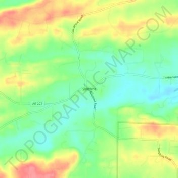
Name: Sunshine topographic map, elevation, terrain.

Location: Sunshine, Garland County, Arkansas, 71968, United States (34.45453 -93.25602 34.49453 -93.21602)

Average elevation: 155 m

Minimum elevation: 122 m

Maximum elevation: 197 m

Other topographic maps

Click on a map to view its topography, its elevation and its terrain.

Mountain Pine

United States > Arkansas > Garland County

Average elevation: 159 m

Rockwell

United States > Arkansas > Garland County > Rockwell

Average elevation: 138 m

Piney

United States > Arkansas > Garland County > Hot Springs

Average elevation: 146 m

Lonsdale

United States > Arkansas > Garland County

Average elevation: 149 m

Gear up for your next adventure:

🧭Orienteering Kit - Tools for map reading and navigation in the wild
🔥Emergency Fire Starter - Reliable ignition source for all weather conditions
🛰️Satellite Messenger - Emergency communication for areas with no cell service
🥾Waterproof Trail Shoes - Shoes designed to handle wet terrain
📷Outdoor Action Camera - Capture high-elevation views and rugged adventures

As an Amazon Associate, this site earns from qualifying purchases at no extra cost to you.