
Kilcruaig topographic map
Click on the map to display elevation.
About this map
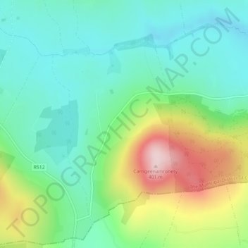
Name: Kilcruaig topographic map, elevation, terrain.
Average elevation: 200 m
Minimum elevation: 113 m
Maximum elevation: 392 m
Other topographic maps
Click on a map to view its topography, its elevation and its terrain.
Glenstal
Ireland > County Limerick > The Municipal District of Cappamore — Kilmallock
Average elevation: 147 m
Tullabeg
Ireland > County Limerick > The Municipal District of Cappamore — Kilmallock
Average elevation: 67 m
Kilmallock
Ireland > County Limerick > The Municipal District of Cappamore — Kilmallock
Average elevation: 89 m
Kilmurry
Ireland > County Limerick > The Municipal District of Cappamore — Kilmallock
Average elevation: 90 m
Kilfinnane
Ireland > County Limerick > The Municipal District of Cappamore — Kilmallock
At an elevation of over 150 metres (500 ft), Kilfinnane is the highest town in County Limerick. It is surrounded on three sides by the Ballyhoura Mountains, and on the fourth side is the "Golden Vale" region that runs through Counties Limerick, Cork, and Tipperary.
Average elevation: 160 m
Darranstown
Ireland > County Limerick > The Municipal District of Cappamore — Kilmallock
Average elevation: 108 m
Ballylanders
Ireland > County Limerick > The Municipal District of Cappamore — Kilmallock
Average elevation: 157 m
Knockainy
Ireland > County Limerick > The Municipal District of Cappamore — Kilmallock
Average elevation: 86 m
Drombane
Ireland > County Limerick > The Municipal District of Cappamore — Kilmallock
Average elevation: 50 m
Aherlow
Ireland > County Limerick > The Municipal District of Cappamore — Kilmallock
Average elevation: 141 m
Kilflynn Particles Parish Union
Ireland > County Limerick > The Municipal District of Cappamore — Kilmallock
Average elevation: 211 m
Cullane South
Ireland > County Limerick > The Municipal District of Cappamore — Kilmallock
Average elevation: 152 m
Clare Glens
Ireland > County Limerick > The Municipal District of Cappamore — Kilmallock
Average elevation: 124 m
Coolnahila (Palmer)
Ireland > County Limerick > The Municipal District of Cappamore — Kilmallock
Average elevation: 39 m
Coolattin
Ireland > County Limerick > The Municipal District of Cappamore — Kilmallock
Average elevation: 222 m
Caherconlish
Ireland > County Limerick > The Municipal District of Cappamore — Kilmallock
Average elevation: 79 m
Coolfree
Ireland > County Limerick > The Municipal District of Cappamore — Kilmallock
Average elevation: 254 m
Tobernea
Ireland > County Limerick > The Municipal District of Cappamore — Kilmallock
Average elevation: 93 m
Anglesborough
Ireland > County Limerick > The Municipal District of Cappamore — Kilmallock
Average elevation: 229 m
Barna
Ireland > County Limerick > The Municipal District of Cappamore — Kilmallock
Average elevation: 249 m
Dromin
Ireland > County Limerick > The Municipal District of Cappamore — Kilmallock
Average elevation: 73 m
Garranbane
Ireland > County Limerick > The Municipal District of Cappamore — Kilmallock
Average elevation: 143 m
Ballyvalode
Ireland > County Limerick > The Municipal District of Cappamore — Kilmallock
Average elevation: 66 m
Ballysallagh
Ireland > County Limerick > The Municipal District of Cappamore — Kilmallock
Average elevation: 80 m
Knocknascrow
Ireland > County Limerick > The Municipal District of Cappamore — Kilmallock
Average elevation: 306 m
Oola
Ireland > County Limerick > The Municipal District of Cappamore — Kilmallock
Average elevation: 77 m
Nicker
Ireland > County Limerick > The Municipal District of Cappamore — Kilmallock
Average elevation: 83 m
Kilmallock
Ireland > County Limerick > The Municipal District of Cappamore — Kilmallock
Average elevation: 90 m
Muingacree
Ireland > County Limerick > The Municipal District of Cappamore — Kilmallock
Average elevation: 268 m
Pallasbeg
Ireland > County Limerick > The Municipal District of Cappamore — Kilmallock
Average elevation: 49 m
Ballinscaula
Ireland > County Limerick > The Municipal District of Cappamore — Kilmallock
Average elevation: 106 m
Toomaline Upper
Ireland > County Limerick > The Municipal District of Cappamore — Kilmallock
Average elevation: 122 m
Ballyshoneen
Ireland > County Limerick > The Municipal District of Cappamore — Kilmallock
Average elevation: 79 m
Doon South
Ireland > County Limerick > The Municipal District of Cappamore — Kilmallock
Average elevation: 101 m
Anglesborough
Ireland > County Limerick > The Municipal District of Cappamore — Kilmallock
Average elevation: 229 m
Doon
Ireland > County Limerick > The Municipal District of Cappamore — Kilmallock
Average elevation: 112 m
Mounteagle
Ireland > County Limerick > The Municipal District of Cappamore — Kilmallock
Average elevation: 63 m
Brickfield
Ireland > County Limerick > The Municipal District of Cappamore — Kilmallock
Average elevation: 123 m
Dead
Ireland > County Limerick > The Municipal District of Cappamore — Kilmallock
Average elevation: 62 m