
Kilfinnane topographic map
Click on the map to display elevation.
Kilfinnane
At an elevation of over 150 metres (500 ft), Kilfinnane is the highest town in County Limerick. It is surrounded on three sides by the Ballyhoura Mountains, and on the fourth side is the "Golden Vale" region that runs through Counties Limerick, Cork, and Tipperary.
About this map
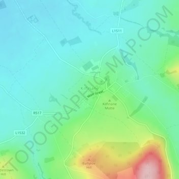
Name: Kilfinnane topographic map, elevation, terrain.
Average elevation: 160 m
Minimum elevation: 108 m
Maximum elevation: 316 m
Other topographic maps
Click on a map to view its topography, its elevation and its terrain.
Kilcruaig
Ireland > County Limerick > The Municipal District of Cappamore — Kilmallock
Average elevation: 200 m
Knockadea
Ireland > County Limerick > The Municipal District of Cappamore — Kilmallock
Average elevation: 203 m
Pallasgreen
Ireland > County Limerick > The Municipal District of Cappamore — Kilmallock
Average elevation: 72 m
Galtymore
Ireland > County Limerick > The Municipal District of Cappamore — Kilmallock
Galtymore or Galteemore (Irish: Cnoc Mór na nGaibhlte, meaning 'big hill of the Galtees') is a mountain in the province of Munster, Ireland. At 917.9 metres (3,011 ft 6 in), it is one of Ireland's highest mountains, being the 12th-highest on the Arderin list, and 14th-highest on the Vandeleur-Lynam list.…
Average elevation: 594 m
Aherlow
Ireland > County Limerick > The Municipal District of Cappamore — Kilmallock
Average elevation: 141 m
Clare Glens
Ireland > County Limerick > The Municipal District of Cappamore — Kilmallock
Average elevation: 124 m
Ardpatrick
Ireland > County Limerick > The Municipal District of Cappamore — Kilmallock
Average elevation: 169 m
Bruff
Ireland > County Limerick > The Municipal District of Cappamore — Kilmallock
Average elevation: 68 m
Bruree
Ireland > County Limerick > The Municipal District of Cappamore — Kilmallock
Average elevation: 62 m