
Thank you for supporting this site ❤️
Make a donation
Make a donation
Gear up for your next adventure:
As an Amazon Associate, this site earns from qualifying purchases at no extra cost to you.
Evansburg topographic map
Click on the map to display elevation.
Thank you for supporting this site ❤️
Make a donation
Make a donation
Gear up for your next adventure:
As an Amazon Associate, this site earns from qualifying purchases at no extra cost to you.
About this map
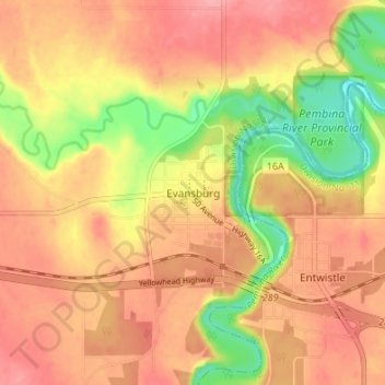
Name: Evansburg topographic map, elevation, terrain.
Location: Evansburg, Division No. 14, Alberta, T0E 0T0, Canada (53.58217 -115.03393 53.62217 -114.99393)
Average elevation: 769 m
Minimum elevation: 706 m
Maximum elevation: 807 m
Division No. 14 trails, hiking, mountain biking, running and outdoor activities
Thank you for supporting this site ❤️
Make a donation
Make a donation
Gear up for your next adventure:
As an Amazon Associate, this site earns from qualifying purchases at no extra cost to you.