Geolocate

Meppen topographic map

Click on the map to display elevation.

About this map

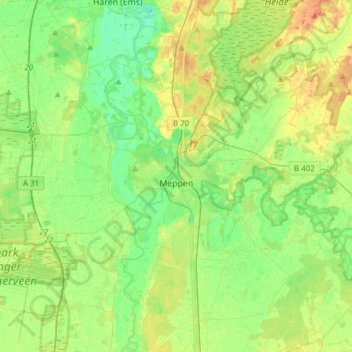
Name: Meppen topographic map, elevation, terrain.

Location: Meppen, Landkreis Emsland, Lower Saxony, Germany (52.62253 7.13514 52.77429 7.44119)

Average elevation: 19 m

Minimum elevation: 5 m

Maximum elevation: 39 m

Other topographic maps

Click on a map to view its topography, its elevation and its terrain.

Elbergen

Germany > Lower Saxony > Landkreis Emsland

Average elevation: 28 m

Mühlenmoor

Germany > Lower Saxony > Landkreis Emsland > Meppen > Helte

Average elevation: 17 m

Emen

Germany > Lower Saxony > Landkreis Emsland > Haren (Ems)

Average elevation: 13 m

Wörmer

Germany > Lower Saxony > Landkreis Emsland > Haren (Ems) > Wesuwe

Average elevation: 12 m

Gear up for your next adventure:

🧴First Aid Kit - Essential first aid supplies for outdoor emergencies
🥾Lightweight Hiking Shoes - Comfortable shoes for day hikes
🦟Insect Repellent - Keep mosquitoes and black flies away in wooded areas
🧦Merino Wool Socks - Moisture-wicking comfort for long-distance hiking
🏃Hydration Running Vest - Carry water and maps close to your body for speed

As an Amazon Associate, this site earns from qualifying purchases at no extra cost to you.