
Balsall Heath topographic map
Interactive map
Click on the map to display elevation.
About this map
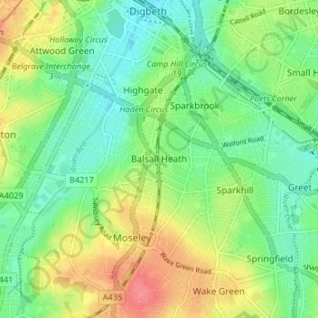
Name: Balsall Heath topographic map, elevation, terrain.
Average elevation: 129 m
Minimum elevation: 103 m
Maximum elevation: 169 m
Other topographic maps
Click on a map to view its topography, its elevation and its terrain.
Stockland Green
Royaume-Uni > Angleterre > Birmingham
Stockland Green, Birmingham, West Midlands Combined Authority, Angleterre, B23 7JG, Royaume-Uni
Average elevation: 114 m
Reddicap Heath
Royaume-Uni > Angleterre > Birmingham > Sutton Coldfield
Reddicap Heath, Sutton Coldfield, Birmingham, West Midlands Combined Authority, Angleterre, B75 7DX, Royaume-Uni
Average elevation: 121 m