
Thank you for supporting this site ❤️
Make a donation
Make a donation
Gear up for your next adventure:
As an Amazon Associate, this site earns from qualifying purchases at no extra cost to you.
Reddicap Heath topographic map
Click on the map to display elevation.
Thank you for supporting this site ❤️
Make a donation
Make a donation
Gear up for your next adventure:
As an Amazon Associate, this site earns from qualifying purchases at no extra cost to you.
About this map
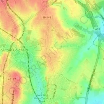
Name: Reddicap Heath topographic map, elevation, terrain.
Average elevation: 121 m
Minimum elevation: 88 m
Maximum elevation: 154 m
Thank you for supporting this site ❤️
Make a donation
Make a donation
Gear up for your next adventure:
As an Amazon Associate, this site earns from qualifying purchases at no extra cost to you.
Other topographic maps
Click on a map to view its topography, its elevation and its terrain.
Black Pool
United Kingdom > England > Birmingham > Sutton Coldfield > Tyburn > Walmley Ash
Average elevation: 95 m
Springhill Plantation
United Kingdom > England > Birmingham > Sutton Coldfield
Average elevation: 146 m