Geolocate

Vinton topographic map

Click on the map to display elevation.

Vinton

Vinton has varied topography, considering its 3.2 square mile size. The above-mentioned lake is at an elevation of 890 feet (270 m) above sea level. The Vinton side of the lake consists of a steep, wooded cliff 150 feet (46 m) in vertical height. Vinton's highest point is on Olney Road, at an elevation of 1,265 feet (386 m), which affords a good view of the adjacent city of Roanoke.

Wikipedia (CC-BY-SA 3.0)

About this map

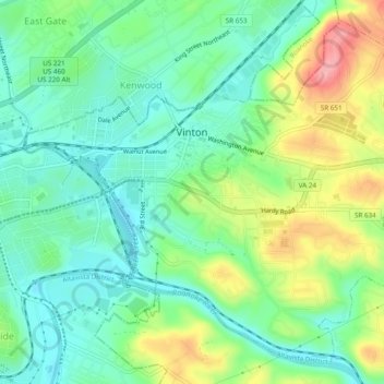
Name: Vinton topographic map, elevation, terrain.

Location: Vinton, Roanoke County, Virginia, United States (37.25785 -79.91800 37.29211 -79.87000)

Average elevation: 304 m

Minimum elevation: 265 m

Maximum elevation: 383 m

Other topographic maps

Click on a map to view its topography, its elevation and its terrain.

Bent Mountain

United States > Virginia > Roanoke County

Average elevation: 826 m

Masons Knob

United States > Virginia > Roanoke County

Average elevation: 650 m

Dragon's Tooth

United States > Virginia > Roanoke County

Average elevation: 687 m

Riverside

United States > Virginia > Roanoke County

Average elevation: 411 m

Branderwood

United States > Virginia > Roanoke County

Average elevation: 405 m

Jones

United States > Virginia > Roanoke County

Average elevation: 389 m

Gear up for your next adventure:

🧰Survival Kit - Essential gear for emergencies in the wilderness
🥾Light Hiking Boots - Lightweight and comfortable boots for day hikes
🥾Durable Hiking Shoes - Long-lasting shoes for frequent hiking
🥘Camping Cookware Set - Compact nesting pots and pans for trail cooking
🛰️Satellite Messenger - Emergency communication for areas with no cell service

As an Amazon Associate, this site earns from qualifying purchases at no extra cost to you.