Geolocate

North Devon topographic map

Click on the map to display elevation.

About this map

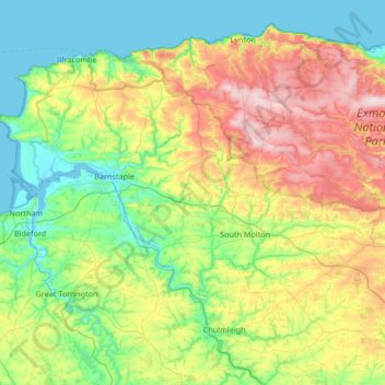
Name: North Devon topographic map, elevation, terrain.

Location: North Devon, Devon, England, United Kingdom (50.87633 -4.26243 51.24684 -3.59446)

Average elevation: 156 m

Minimum elevation: -1 m

Maximum elevation: 509 m

Other topographic maps

Click on a map to view its topography, its elevation and its terrain.

Orway

United Kingdom > England > Devon > Mid Devon > Saint Hill

Average elevation: 155 m

Water

United Kingdom > England > Devon > Teignbridge > Water

Average elevation: 261 m

Dunsford

United Kingdom > England > Devon > Teignbridge

Average elevation: 139 m

Gear up for your next adventure:

🦌Outdoor Trail Camera - Monitor wildlife activity near your favorite spots
🪑Insulated Seat Pad - Protect your seat from cold rocks and wet logs
🥾Trekking Boots - Durable boots for long-distance trekking
💡LED Camping Lantern - Illuminate your campsite with long-lasting lanterns
🔭Compact Binoculars - Lightweight optics for scouting trails and wildlife

As an Amazon Associate, this site earns from qualifying purchases at no extra cost to you.