
Make a donation
Gear up for your next adventure:
As an Amazon Associate, this site earns from qualifying purchases at no extra cost to you.
Zona 12 topographic map
Click on the map to display elevation.
Make a donation
Gear up for your next adventure:
As an Amazon Associate, this site earns from qualifying purchases at no extra cost to you.
About this map
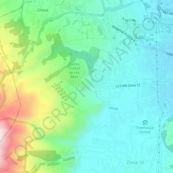
Name: Zona 12 topographic map, elevation, terrain.
Location: Zona 12, Quetzaltenango, 09001, Guatemala (14.81202 -91.57419 14.85202 -91.53419)
Average elevation: 2,522 m
Minimum elevation: 2,354 m
Maximum elevation: 3,003 m
Make a donation
Gear up for your next adventure:
As an Amazon Associate, this site earns from qualifying purchases at no extra cost to you.
Other topographic maps
Click on a map to view its topography, its elevation and its terrain.
Huitán
Huitán (Spanish pronunciation: [wiˈtan]) is a municipality in the Quetzaltenango department of Guatemala, situated on 16 km2 at 2600 m altitude, North-West from Quetzaltenango.
Average elevation: 2,667 m
Municipio de Quetzaltenango
Quetzaltenango (Spanish pronunciation: [keˌtsal.teˈnaŋ.ɡo], also known by its Maya name Xelajú [ʃelaˈχu] or Xela [ˈʃela]) is a municipality and namesake department in western Guatemala. The city is located in a mountain valley at an elevation of 2,330 meters (7,640 feet) above sea level at its lowest…
Average elevation: 2,489 m
Municipio de Quetzaltenango
Quetzaltenango (Spanish pronunciation: [ketsalteˈnaŋɡo], also known by its Maya name Xelajú [ʃelaˈχu] or Xela [ˈʃela]) is both the seat of the namesake Department and municipality, in Guatemala. The city is located in a mountain valley at an elevation of 2,330 meters (7,640 feet) above sea level at…
Average elevation: 2,489 m
Make a donation
Gear up for your next adventure:
As an Amazon Associate, this site earns from qualifying purchases at no extra cost to you.
Quetzaltenango
Quetzaltenango (Spanish pronunciation: [keˌtsal.teˈnaŋ.ɡo], also known by its Maya name Xelajú [ʃelaˈχu] or Xela [ˈʃela]) is a municipality and namesake department in western Guatemala. The city is located in a mountain valley at an elevation of 2,330 meters (7,640 feet) above sea level at its lowest…
Average elevation: 2,456 m
Make a donation
Gear up for your next adventure:
As an Amazon Associate, this site earns from qualifying purchases at no extra cost to you.