
Make a donation
Gear up for your next adventure:
As an Amazon Associate, this site earns from qualifying purchases at no extra cost to you.
Municipio de Quetzaltenango topographic map
Click on the map to display elevation.
Make a donation
Gear up for your next adventure:
As an Amazon Associate, this site earns from qualifying purchases at no extra cost to you.
Municipio de Quetzaltenango
Quetzaltenango (Spanish pronunciation: [keˌtsal.teˈnaŋ.ɡo], also known by its Maya name Xelajú [ʃelaˈχu] or Xela [ˈʃela]) is a municipality and namesake department in western Guatemala. The city is located in a mountain valley at an elevation of 2,330 meters (7,640 feet) above sea level at its lowest part. Inside the city, it can reach above 2,400 m (7,900 ft).
Make a donation
Gear up for your next adventure:
As an Amazon Associate, this site earns from qualifying purchases at no extra cost to you.
About this map
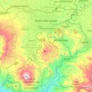
Name: Municipio de Quetzaltenango topographic map, elevation, terrain.
Average elevation: 2,489 m
Minimum elevation: 1,605 m
Maximum elevation: 3,750 m
Make a donation
Gear up for your next adventure:
As an Amazon Associate, this site earns from qualifying purchases at no extra cost to you.
Other topographic maps
Click on a map to view its topography, its elevation and its terrain.