
Make a donation
Gear up for your next adventure:
As an Amazon Associate, this site earns from qualifying purchases at no extra cost to you.
Yalova topographic map
Click on the map to display elevation.
Make a donation
Gear up for your next adventure:
As an Amazon Associate, this site earns from qualifying purchases at no extra cost to you.
About this map
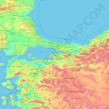
Name: Yalova topographic map, elevation, terrain.
Location: Yalova, Marmara Region, Turkey (37.97954 26.56870 43.17954 31.76870)
Average elevation: 404 m
Minimum elevation: -2 m
Maximum elevation: 2,703 m
Make a donation
Gear up for your next adventure:
As an Amazon Associate, this site earns from qualifying purchases at no extra cost to you.
Other topographic maps
Click on a map to view its topography, its elevation and its terrain.
Make a donation
Gear up for your next adventure:
As an Amazon Associate, this site earns from qualifying purchases at no extra cost to you.
Make a donation
Gear up for your next adventure:
As an Amazon Associate, this site earns from qualifying purchases at no extra cost to you.
Antalya
The highest point of the Taurus mountains is Akdağ at an altitude of 3025 metres. Located to the northwest of the city centre and at a distance of 50 km (31 mi) is the Saklıkent ski and recreation centre on Beydağları. Here one can ski and then go down to the shore and into the sea during the months of…
Average elevation: 644 m
Make a donation
Gear up for your next adventure:
As an Amazon Associate, this site earns from qualifying purchases at no extra cost to you.
Make a donation
Gear up for your next adventure:
As an Amazon Associate, this site earns from qualifying purchases at no extra cost to you.
Make a donation
Gear up for your next adventure:
As an Amazon Associate, this site earns from qualifying purchases at no extra cost to you.
Make a donation
Gear up for your next adventure:
As an Amazon Associate, this site earns from qualifying purchases at no extra cost to you.
Taurus Mountains
The mountains have a Mediterranean climate, with dry summers and rainy winters. Temperatures vary with elevation, with warm winters on the lower coastal slopes and cold winters in the high mountains and in the interior.
Average elevation: 828 m
Oludeniz
Ölüdeniz offer a variety of diving opportunities with regard to its crystal clear waters and rich underwater caves and fauna. Scuba diving is the most popular underwater activity. Local diving agencies provide courses and required scuba diving licences. Snorkelling is another diving activity and many sites…
Average elevation: 541 m
Make a donation
Gear up for your next adventure:
As an Amazon Associate, this site earns from qualifying purchases at no extra cost to you.
Mucur
Mucur, formerly known as Niza, is a town in Kırşehir Province in the Central Anatolia region of Turkey. It is the seat of Mucur District. Its population is 13,350 (2022). It is known as a center for the production and sale of prayer rugs and other decorative rugs. Its elevation is 1,120 m (3,670 ft).
Average elevation: 1,119 m
Gemlik
Gemlik has a hot-summer Mediterranean climate (Köppen climate classification: Csa) with cool and rainy winters, and hot and dry summers. The driest month is July with an average of 22 mm (0.87 in) of rainfall. The wettest month is December with an average of 98 mm (3.9 in) of precipitation. Although a…
Average elevation: 356 m
Make a donation
Gear up for your next adventure:
As an Amazon Associate, this site earns from qualifying purchases at no extra cost to you.
Amasra
In the late 8th century its bishop obtained from the Byzantine Emperor its elevation to the rank of autocephalous archeparchy. It is listed as such in the Notitia Episcopatuum attributed to Basil the Armenian (c. 840) and in that of Leo VI the Wise (early 10th century).
Average elevation: 121 m
Make a donation
Gear up for your next adventure:
As an Amazon Associate, this site earns from qualifying purchases at no extra cost to you.
Köroğlu Mountains
Two ski resorts near Köroğlu Tepesi were inaugurated: Kartalkaya and Sarialan, with elevations between 1,900 m (6,233 ft) and 2,378 m (7,802 ft).
Average elevation: 854 m
Make a donation
Gear up for your next adventure:
As an Amazon Associate, this site earns from qualifying purchases at no extra cost to you.
Make a donation
Gear up for your next adventure:
As an Amazon Associate, this site earns from qualifying purchases at no extra cost to you.
Make a donation
Gear up for your next adventure:
As an Amazon Associate, this site earns from qualifying purchases at no extra cost to you.
Make a donation
Gear up for your next adventure:
As an Amazon Associate, this site earns from qualifying purchases at no extra cost to you.
Make a donation
Gear up for your next adventure:
As an Amazon Associate, this site earns from qualifying purchases at no extra cost to you.
Make a donation
Gear up for your next adventure:
As an Amazon Associate, this site earns from qualifying purchases at no extra cost to you.
Make a donation
Gear up for your next adventure:
As an Amazon Associate, this site earns from qualifying purchases at no extra cost to you.
Karagöl Sahara National Park
The national park covers an area of 3,251 ha (8,030 acres) at an average elevation of 1,800 m (5,900 ft) above mean sea level.
Average elevation: 1,885 m
Make a donation
Gear up for your next adventure:
As an Amazon Associate, this site earns from qualifying purchases at no extra cost to you.
Gerede
Gerede is a town in Bolu Province in the Black Sea region of Turkey. It is located on the highway from Istanbul to Ankara (approximately 150 km (93.21 mi) from Ankara, where the road to the Black Sea coast branches off). It is the seat of Gerede District. Its population is 23,547 (2021). Elevation is about…
Average elevation: 1,368 m
Make a donation
Gear up for your next adventure:
As an Amazon Associate, this site earns from qualifying purchases at no extra cost to you.
Bağcılar
Bağcılar is located on the European side of Istanbul, within the service boundaries of Istanbul Metropolitan Municipality. Its area is 22 km2 (8.5 sq mi). The district is now known as an immigrant quarter. It lies between E-5 and TEM. In the south Bahçelievler, in the west Küçükçekmece, in the northwest…
Average elevation: 85 m
Make a donation
Gear up for your next adventure:
As an Amazon Associate, this site earns from qualifying purchases at no extra cost to you.
Make a donation
Gear up for your next adventure:
As an Amazon Associate, this site earns from qualifying purchases at no extra cost to you.
Make a donation
Gear up for your next adventure:
As an Amazon Associate, this site earns from qualifying purchases at no extra cost to you.
Make a donation
Gear up for your next adventure:
As an Amazon Associate, this site earns from qualifying purchases at no extra cost to you.
Make a donation
Gear up for your next adventure:
As an Amazon Associate, this site earns from qualifying purchases at no extra cost to you.
Make a donation
Gear up for your next adventure:
As an Amazon Associate, this site earns from qualifying purchases at no extra cost to you.
Make a donation
Gear up for your next adventure:
As an Amazon Associate, this site earns from qualifying purchases at no extra cost to you.