Geolocate

Oludeniz topographic map

Click on the map to display elevation.

About this map

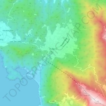
Name: Oludeniz topographic map, elevation, terrain.

Location: Oludeniz, Fethiye, Muğla, Aegean Region, Turkey (36.53030 29.10602 36.60440 29.21068)

Average elevation: 541 m

Minimum elevation: 0 m

Maximum elevation: 1,965 m

Other topographic maps

Click on a map to view its topography, its elevation and its terrain.

Nif

Turkey > Fethiye

Average elevation: 1,075 m

Göcek

Turkey > Fethiye

Average elevation: 106 m

Kayaköy

Turkey > Fethiye

Average elevation: 223 m

Gökçeovacık

Turkey > Fethiye

Average elevation: 574 m

Kayaköy

Turkey > Fethiye

Average elevation: 223 m

Çenger

Turkey > Fethiye

Average elevation: 671 m

Gear up for your next adventure:

🧶550 Survival Paracord - Versatile utility cord for emergency repairs and rigging
🧴Bear Spray Holster - Quick-access carry for essential Canadian wilderness safety
🥾Trekking Boots - Durable boots for long-distance trekking
🧤Thermal Hiking Gloves - Grip-enhanced gloves for cold-weather altitude trekking
🔦UV Flashlight - Detect minerals or specific insects in the dark

As an Amazon Associate, this site earns from qualifying purchases at no extra cost to you.